This application exists to try to do some validation checking of OSM relations, keeping track of their reliability over time. The intention is that, if an organization of some kinds wants to rely on a relation in their operations, they need to be able to decide when the relation can be relied upon and when it cannot.
For example, the is a relation set for 'California Cities' that has 477 members. The entries for each city points to an osm type, such as 'relation' or 'way', and an osm id. West Sacramento is a relation with an id value equal to 7615151. There is a link associated with the city so that one can go to https://www.openstreetmap.org/relation/7615151 and see the relation.
The referential integrity checking that is done is very simple, but it seems to be doing an adequate job. The checking looks through all of the parts of the relation and verifies that they connect to something. I do handle disconnected cycles. One might think that a city would not have disconnected boundaries, but some cities have, for example, an airport. This can be 5 miles outside of town. The town boundary may then go around the town itself and also around the airport with no land between them in the city boundaries. And, of course, the counties in Calfornia do completely tile the state, but cities do not and many other boundaries are like this.
| Sunnyvale, CA | El Monte, CA |
|---|---|
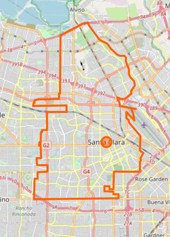 |
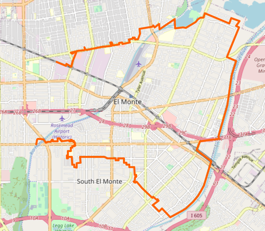 |
| Looking good! | Not so good. And searching for "el monte california" reveals no relation or way that is better. |
There are other boundaries I am interested in. For example, I would like to have school districts of California. But it seems that the districts have mailing addresses of buildings or residences in their district and nothing else. I am fairly sure that school district boundary information is stored somewhere relative to TIGER data but I cannot find it. And that would only get one part of the way to the end of job, of course. OSM has connections to TIGER data but they do not seem to be comprehensive. There is actually an agency in California that is responsible for determining boundaries between entities. They are involved, for example, when city coundaries get defined or when a new school district is peeled off of an existing one. But LAFCO (the Local Agency Formation Commission) is a bit opaque. Ordinary people are not usually their customers and their map data is not easy to find. Someone with Code for America actually pointed me to an unlinked-to directory in LAFCO's site but it had a bunch of randomly-named files with ESRI data, which I do not work with and do not have time to unravel.
So, there it is.
CC BY 4.0, Ray Kiddy, 2020.